1861 Arrival of the railway named Porthywaen Junction to serve the limestone quarry. It ran from a junction called Porthywaen Junction but was renamed Llynclys Junction when TVLR opened just north of Llynclys station. the branch line ran for approx 1 and 3/4 miles to the lime kilns at Porthywaen and serviced other quarries on route. Date May.
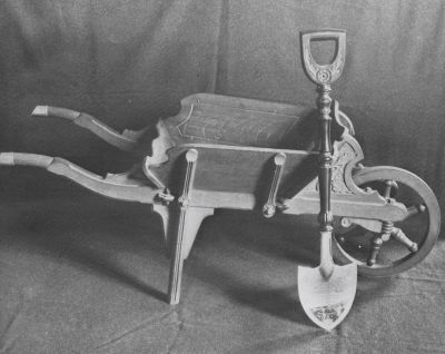
On 12th November 1899, the first sods were cut in a field near to the National School, Porthywaen by the Countess of Powys, using an ornate wheelbarrow and silver spade. Additional sods were cut by Mrs Leslie, Bryntanat, Mrs Stanley Leighton, Mrs Humphreys-Owen, Mrs Herbert Roberts, Mrs Pryce-Jones, Mrs W.H.Thomas and Mrs A.J.Collin.
1904 a special train was laid on from Oswestry to carry officials and guests which halted at Porthywaen crossing. Here the gates were closed across the line secured by a silver chain and a padlock. Lady Wynn performed the opening ceremony by unlocking the padlock with a gold key.
1921 The TVLR was taken out of receivership when it was taken over by The Cambrian Railways Company.
|
|
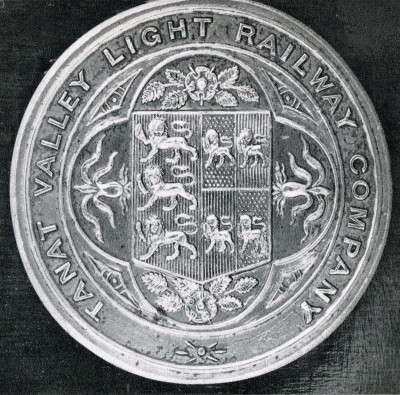
Original Company seal of the Tanat Valley Light Railway
Source Ken Owen |
|
|
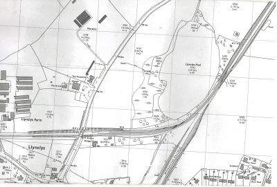
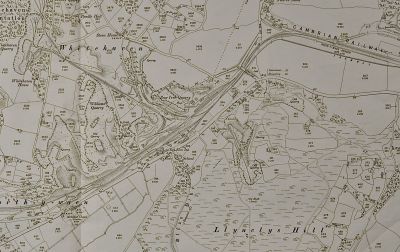
1901 map showing the junction of the Tanat Valley Light Railway with the Cambrian Railways at Llynclys Junction.
Source Wilf Jones |
|
.jpg)
|
Letter dated 29th September 1904 from the Cambrian Railways to the solicitors acting for the Tanat Valley Railway advising on the tenders to build the stations up the Tanat Valley line.
Source Mr Johnson. |
|
|
Wheelbarrow and silver spade used in the ceremony of the cutting the first sods, on 12th November 1899, and presented to the Countess of Powys by the Chairman and Board of the Railway. These are now preserved in Powys Castle at Welshpool.. |
|
|
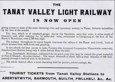
Advert from local paper when the Tanat Valley Railway opened. |
|

|
1st timetable of the Tanat Valley Light Railway, published in the Oswestry Advertiser.
Source Oswestry Advertizer. |
|
|
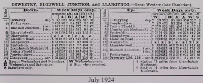
Timetable of the TVLR in July 1924. |
|
|
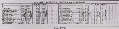
Timetable of the TVLR June 1950 |
|

|
Mile post at the junction. The top numeral denotes the miles and the lower below the horizontal line indicates the quarter miles and would show it by the numeral 1, 11, or 111 showing quarter, half and three quarter mile. |
|
|
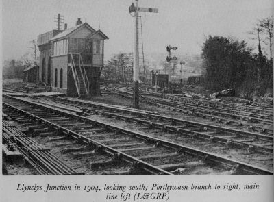
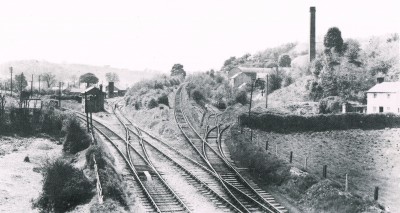
Llynclys Junction at the start of the Tanat Valley Line. |
|
|
Another excellent photo of the start of the Tanat Valley line at Llynclys junction. The mile post in the above photo is located to the right out of sight of the photographer. The metal post is still in the ground but the actual wooden top with the numerals is missing. |
|
.jpg)
|
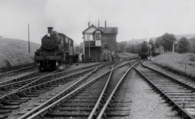
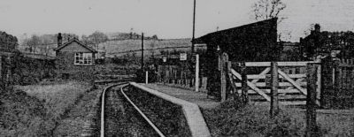
Llynclys Junction showing the signal box, water tower. 2 x workmens huts(Pway huts) and the water pump in the foreground taking water from the stream leading out of Llynclys pool, which was used to replenish the steam engines. |
|
|
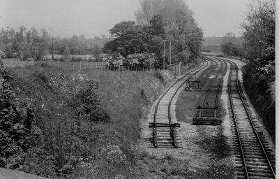
Photo taken from the A483 bridge looking past the sidings towards the main line Llynclys Junction. Note the Weighbridge half way along the left hand siding. |
|
|
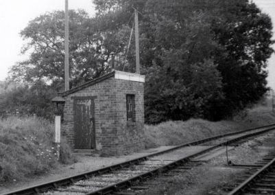
Weighbridge at Llynclys junction. The base of this building is still in the undergrowth. |
|
|
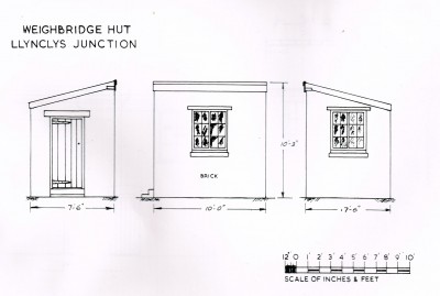
Measurements of the weighbridge hut
Source Tanat Valley Light Railway by Mike Lloyd |
|
|
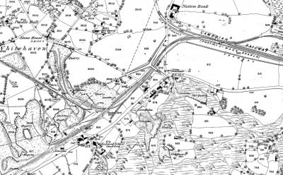
1875 map showing the Cambrian Railway coming to the Porthywaen Quarry area. Note the old Thomas Savin track from the Coedygo coalmines coming to join the Cambrian Railway from the north. This track was dismantled after Savin went bankrupt in 1869. This map shows that the main line ended in a woodyard and also shows the Crickheath Tramway crossing the main line and going into the Pear Tree Quarry.
Source Wilf Jones |
|
|
Photo of the Porthywaen area showing the intricate rail layouts leading to Pear Tree Quarry, the long incline going up to further quarries and the siding to the right of the signal box leading to Pear Treet Quarry under the incline, and also the truck workshops near to the Red Lion pub. Date believed to be 1940's |
|

|
Sad photo of the demise of the railways going into the quarries. in 1976. |
|

|
Photo showing the mile post at Porthywaen Halt indicating 1 mile from the junction with the Cambrian Railway. |
|
|
1901 map showing how the Porthywaen area was developing around the Quarries, prior to the Tanat Valley Railway being built.
Source Wilf Jones |
|
|
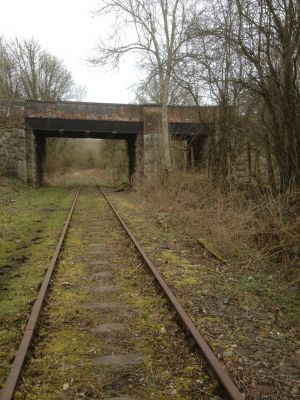
Recent photo of the bridge which was constructed to carry the road over the Cambrian Railway and the Crickheath Tramway. The date is on the large girder spanning both tracks"Brymbo 1861". The right hand span is the Crickheath Tramway bridge. The view is looking from Porthywaen towards Llynclys. See the above 1875 map.
Source Ken Owen |
|

|
1926 map showing the Tanat Valley line leading from Porthywaen up the Tanat Valley.
Source Wilf Jones |
|
|
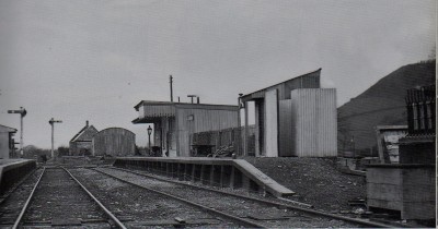
Porthywaen Station 1948. |
|
|
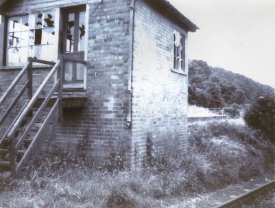
Photo of Porthywaen signal box prior to demolition Date probably 1970's. |
|
|
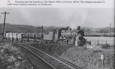
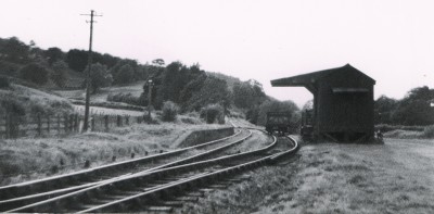
Good photo of a steam engine reversing from the Nantmawr branch line, onto the main Tanat Valley line loaded with ballast from the Blodwel Quarry. This would have been then taken to Llynclys junction and then onward to its eventual destination. Note the 2and a quarter miles mile post at this junction. Unfortunately this post has now been removed. |
|
|
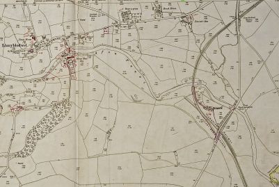
1901 map showing the Nantmawr branch line prior to the building of the Tanat Valley line. At the top right of the map is where the line goes under the Llansantffraid Road and this is where the present Cambrian Heritage Railway track ends at a buffer. It is interesting to note that in 1901 it was called Llanyblodwel Goods station. It is worth noting also that South of this bridge was built a cutting to accomodate a triangular turn round when the Tanat Valley line was eventually built but this did not happen. |
|

|
1904 photo of Llanyblodwel Junction Station |
|
|
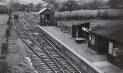
Blodwel Junction station photo taken in the 1940's. |
|
.jpg)
|
Nice photo of a passenger train travelling towards Llynclys junction with the spire of Llanyblodwel church in the background. |
|
|
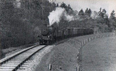
Photo of a goods train (hauled by 46524 an Ivatt Class 2 British Rail built at Swindon in 1953), heading East from Llangynog having just passed Glanyrafon on a long curve before Llanyblodwel Station.
Source Rod Lloyd. |
|
|
Goods Station at Penybont L.E known as Llansilin Road. This was just a goods station with a platform which is still in existence and also a large goods shed..
Source Ken Owen |
|

|
Track layout of the Llansilin Road Station site dated 1966.
Source The Tanat Valley by Wilfred J. Wren |
|

|
1949 6inch to the mile map showing Llansilin Road goods station. Note the pub nearby called The New Inn which is still there but is now a private dwelling.
Source Ken Owen |
|
|
Llangedwyn station believed to be in the 1920's.
Source Branch Lines around Oswestry |
|
.jpg)
|
Excellent photo and the Llangynog train crossing the main road. There was a fatal accident at this location where a doctor was crossing the railway in his car and collided with the train.
Source Ken Owen |
|
|
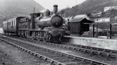
Llangynog station believed to be in the 1930's. |
|

|
An account of the last working train on the Tanat Valley line and the Nantmawr Mineral Line.
"The Tanat Valley" by Wilfred J.Wren. |
|
|
|
|
|
|
|
|
|
|
|
|
|
|
|
|
|
|
|
|
|
|
|
|


.jpg)


.jpg)


.jpg)


.jpg)

